
Words vs. Images: How to Choose the Right Satellite Safety Tier for Your Next Expedition
- GMagid

- 1 day ago
- 5 min read
If you ask any seasoned overlander, solo commercial driver, or offshore skipper what their number one safety tool is when cell signal drops to zero, they will all give you the same answer: a reliable satellite communicator.
For more than a decade, standard text-based satellite messaging has been the gold standard for global tracking. The ability to send a quick check-in text like "Arrived safely at camp" or ping your exact coordinates to a recovery vehicle is a massive safety asset that has saved countless lives across the African continent. It is a foundational tool that every off-grid traveller should have in their glovebox or grab-bag.
However, as overland routes push deeper into uncharted territories, remote cross-border tracks get more punishing, and technology evolves, a new operational question has emerged:
What happens when your situation is too complex to explain in a basic 160-character text?

Introducing the Premium Tier: Visual Satellite Ecosystems
This is exactly where the new Garmin GPSMAP® H1i Plus steps onto the scene. It doesn't replace the reliable text-based devices we’ve all come to rely on for weekend trips—instead, it introduces a premium, high-capability tier for serious expeditions.
By integrating next-generation inReach® Plus satellite technology, this military-grade handheld allows you to transmit compressed voice notes and crisp digital photos completely over global satellite networks, even when you are thousands of kilometres away from the nearest cell tower.
It isn't about declaring text dead; it’s about choosing whether your specific mission requires eyes on the ground.
The Breakdown: When is Text Enough, and When Do You Need Visuals?
To help map out your loadout for your next trip, let's break down the two primary tiers of off-grid satellite communication.
Tier 1: Standard Text Tracking & Messaging (The Essentials)
The Mission Profiles: Weekend 4x4 trails, local hiking loops, standard hunting safaris, or convoy-based travel along well-travelled overlanding corridors (like the standard routes through Botswana or Namibia).
How it Protects You: Standard text-based satellite messengers excel at keeping a digital breadcrumb trail. They allow friends and family to monitor your location in real-time via an interactive map, let you send pre-set "all good" messages, and offer a dedicated, guarded SOS button for emergencies.
The Verdict: If you are traveling in a group or staying within striking distance of recovery infrastructure, standard text units are highly effective, lightweight, and offer the baseline insurance every traveller needs.
Tier 2: Audio & Visual Streaming (The Premium Upgrade)
The Mission Profiles: Solo cross-border expeditions, deep exploratory mapping, commercial off-road tour guiding, heavy industrial field operations, or long-range deep-sea maritime tracking.
How it Protects You: The GPSMAP® H1i Plus is engineered for situations where miscommunication isn't an option. By adding photo and voice data capabilities to the global Iridium® satellite network, it changes how field issues are managed.
The Verdict: If you operate under high-consequence conditions where an extraction or a mechanical failure could stall your entire project, the visual and audio verification provided by the H1i Plus is a crucial tool.
3 Real-World Scenarios Where a Photo Changes the Outcome
To understand why visual satellite tech is gaining rapid traction among professional explorers and overlanders in South Africa, consider how a crisis unfolds in the field:
1. Remote Mechanical & Structural Diagnostics
Imagine you are traversing a remote section of the Richtersveld or a forgotten track in northern Mozambique. Your vehicle hits a hidden washaway, and you hear a sharp crack from the undercarriage. You crawl underneath and find a fractured suspension leaf spring or a leaking differential casing.
With text: You try to type out a description of the crack and the exact part name over 160 characters. A support team back home has to guess what tools or spares to dispatch.
With the H1i Plus: You snap a clear, high-contrast photo of the broken component and beam it directly to your mechanic or recovery team. They see the exact extent of the damage, pack the precise replacement hardware, and head straight to your coordinates.
2. Real-Time Emergency Medical Guidance
Medical crises in the deep bush are incredibly stressful. If a team member encounters a severe wildlife sting, an unknown allergic reaction, or a complex physical injury, verbal descriptions over text often leave critical gaps.
With text: Phrases like "bad rash" or "deep cut" don't give an emergency physician enough context to diagnose the severity.
With the H1i Plus: You take a photo of the wound or skin reaction and stream it directly through the satellite network. Remote medical personnel can evaluate the wound visually, assess the severity, and text you back exact, step-by-step first aid protocols to stabilize the patient while an extraction team is mobilized.
3. Confirming Asset & Route Conditions
For commercial tour operators, anti-poaching units, or logistics managers, getting visual confirmation of route blockages (like flooded river crossings or fallen trees) or asset conditions is vital for making rapid tactical decisions. A quick photo sent to head office can save a convoy hours of back-tracking.
Uncompromised Navigation: The Core Hardware Power
Beyond its communication capabilities, the H1i Plus is built on Garmin’s most advanced navigation framework. It is built strictly to military durability standards (MIL-STD-810) for thermal, shock, and water resistance, making it practically indestructible in harsh conditions.
Multi-Band GNSS Technology: By accessing multiple global navigation satellite frequencies simultaneously, the device maintains pinpoint location accuracy in dense bushveld, deep rock canyons, or extreme weather where standard GPS units lose reception.
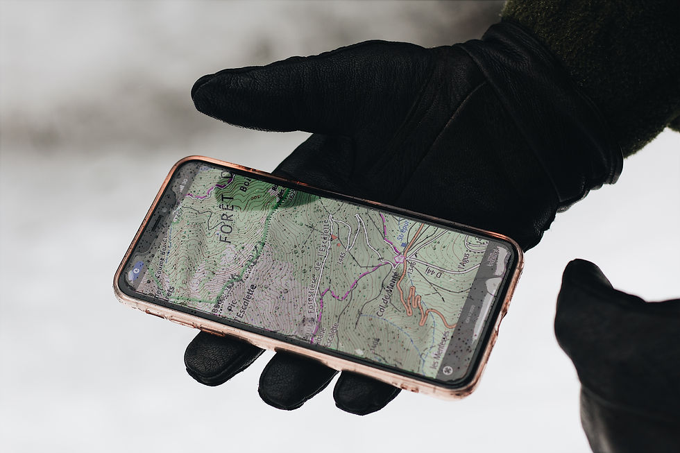
Preloaded TopoActive Maps: Features highly detailed, fully routable topographic maps mapping out terrain contours, off-road tracks, elevations, and geographic points of interest.
Expedition-Ready Battery Life: The unit is optimized for ultra-low power consumption, yielding Up to 145 hours of battery life across all satellite systems in Multi-band mode, stretching up to 425 hours in specialized expedition mode tracking.
Choosing the Right Tool for Your Glovebox
Satellite communication is not a one-size-fits-all solution, and it shouldn't be treated as one.
If your travel involves predictable routes, fleet convoys, or weekend getaways, a standard text-based satellite tracker remains a reliable, cost-effective safety tool. But if your operations demand absolute visual verification, high-fidelity audio check-ins, and top-tier military-grade navigation, the Garmin GPSMAP® H1i Plus stands completely on its own.
Don't wait until you are stranded in the middle of a remote territory wishing you could send a photo of the problem. Match your safety gear to the reality of your destination.
Ready to Upgrade Your Off-Grid Safety?
At Satcomms South Africa, we specialize in tailoring satellite hardware and global airtime subscription packages to match your exact operational needs.
💬 Have questions about satellite coverage, airtime activation, or setting up your device? Contact our local support team directly via email for expert guidance.


Comments